|
by WONG Nyuk Hien
 rban development is unavoidable as part of the nation's economic growth. With the attraction of developed cities, neighbouring towns and villages suffer rural-urban migration. The influx of people increases the need to develop bigger cities. Now, about half of the world's population is currently living in big cities and the numbers are estimated to go up to five billion people by the year 2030. Singapore is not immune to this problem. rban development is unavoidable as part of the nation's economic growth. With the attraction of developed cities, neighbouring towns and villages suffer rural-urban migration. The influx of people increases the need to develop bigger cities. Now, about half of the world's population is currently living in big cities and the numbers are estimated to go up to five billion people by the year 2030. Singapore is not immune to this problem.
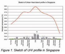 The environmental problem that is closely related to urbanization is Urban Heat Island (UHI) effect. UHI is a phenomenon when the air temperature in the city is significantly warmer than in the sub-urban and rural area. This phenomenon is mainly due to the loss of vegetation areas which are often sacrificed for urban development. Based on the temperature measurements conducted in Singapore, the highest air temperature of 28.4oC was found in Central Business District (CBD) area that has less vegetation. Meanwhile, the lowest air temperature of 24.0oC was detected in the north-western part of Singapore, where the forest is located. Figure 1 depicts the UHI profile of Singapore, with the intensity of 4.4oC. The environmental problem that is closely related to urbanization is Urban Heat Island (UHI) effect. UHI is a phenomenon when the air temperature in the city is significantly warmer than in the sub-urban and rural area. This phenomenon is mainly due to the loss of vegetation areas which are often sacrificed for urban development. Based on the temperature measurements conducted in Singapore, the highest air temperature of 28.4oC was found in Central Business District (CBD) area that has less vegetation. Meanwhile, the lowest air temperature of 24.0oC was detected in the north-western part of Singapore, where the forest is located. Figure 1 depicts the UHI profile of Singapore, with the intensity of 4.4oC.
As many people may have heard, the Singapore government has a plan to increase its population to 6.5 million from the current 4.5 million. With this increase in population, the country will need new urban development to accommodate the social and economical needs of the people. The development of the second Central Business District (CBD) in Marina Bay and the Jurong Lake District all work towards this purpose. Without careful planning of the urban landscape, the higher UHI intensity will inevitably lead to a rise in urban air temperatures. Then, not only will the outdoor condition be unbearably hot, the consumption of energy for cooling of buildings will also increase significantly.
Urban climatic mapping - one way of assessing the urban climate condition - has gained popularity in recent years. It is a colour coded map which provides information on the hot and cool spots developed by means of the Geographical Information System (GIS). This method has been used for assessment from the regional scale of 1:100,000 to the urban scale of 1:5000. Currently, estate development still lacks an assessment tool for its existing condition and future planning. In our latest studies, we have employed the GIS as an assessment tool for an estate or neighbourhood development.
A research was conducted to assess the microclimatic condition of National University of Singapore's Kent Ridge campus. Its size is approximately 150 hectares and can be considered as a small scale "city". The plot homes educational buildings, high-rise and low-rise residential buildings, a museum and cultural centre, sport facilities and administration offices. Most of the greenery condition can be categorized as less dense greenery. The campus has open fields and the roads are peppered with trees. Even between buildings, trees are planted every three to ten metres. The trees provide low thermal benefit, which is mainly for aesthetical purpose. The greenery area along Kent Ridge Road seems like a "rural" area with cooler ambient temperature.
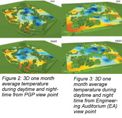 Generated temperature maps superimposed with 3D NUS Kent Ridge Campus GIS model are shown in Figure 2 and 3. In general, cool spots are mostly located in the area that has large and dense greenery condition. The coolest location was found at the Water Tank which is located in the middle of Kent Ridge lush greenery. Other cool spots are also identified in the car parks, where large trees provide much shade. This evidence shows the importance of trees, especially mature ones, in reducing ambient temperature. Generated temperature maps superimposed with 3D NUS Kent Ridge Campus GIS model are shown in Figure 2 and 3. In general, cool spots are mostly located in the area that has large and dense greenery condition. The coolest location was found at the Water Tank which is located in the middle of Kent Ridge lush greenery. Other cool spots are also identified in the car parks, where large trees provide much shade. This evidence shows the importance of trees, especially mature ones, in reducing ambient temperature.
Conversely, hot spots are located in areas with sparse greenery and large pavement areas between the buildings. The noticeable hot locations were found at Engineering Auditorium - EA, and Prince George's Park Canteen. The daytime heat island intensity reaches about 3.2K, with the coolest area near the Water Tank. Meanwhile the night time heat island intensity is about 2K.
In the day, PGP heats up due to lack of greenery (see Figure 2). At night, the temperature remains high but the heat spreads over a larger area. Heat that accumulated in the building in the day, begins to disperse into the environment at night. Meanwhile in the dense greenery area (Water Tank), the condition is more stable. From Figure 3, it can be seen that during daytime, Engineering Auditorium is heated up (red color) due to a large open pavement area and during the night the temperature is reduced since in open area, the heat is easily released. This is a reverse phenomenon as compared with the PGP area.
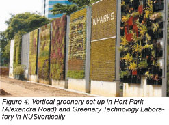 It is very clear that parks or clusters of trees are able to provide shading and cooling throughout the day. However, not every estate development has the opportunity to introduce more vegetation due to space constraints. To make space for greenery, planners and architects are looking into the introduction of vegetations vertically into buildings. The idea of vertical greenery is not a new concept but there is still limited research in this area. With Dr Chen Yu and the full support of NUS' Department of Building, we have established the Green Technology Laboratory. It showcases the state-of-the-art technologies of strategically introducing plants into buildings, such as green roofs and vertical green walls for the tropical climate. Working together with National Parks Board (NParks) and Building and Construction Authority (BCA), different vertical greenery systems were also set up in Hort Park (Alexandra Road) to study their thermal performances (see Figure 4). It is very clear that parks or clusters of trees are able to provide shading and cooling throughout the day. However, not every estate development has the opportunity to introduce more vegetation due to space constraints. To make space for greenery, planners and architects are looking into the introduction of vegetations vertically into buildings. The idea of vertical greenery is not a new concept but there is still limited research in this area. With Dr Chen Yu and the full support of NUS' Department of Building, we have established the Green Technology Laboratory. It showcases the state-of-the-art technologies of strategically introducing plants into buildings, such as green roofs and vertical green walls for the tropical climate. Working together with National Parks Board (NParks) and Building and Construction Authority (BCA), different vertical greenery systems were also set up in Hort Park (Alexandra Road) to study their thermal performances (see Figure 4).
Based on the species of plants, types of growing media and construction method, vertical greenery can be grouped into three categories - hanging-down, wall-climbing and module types. By planting them on every storey, plants which hang down form a complete vertical green belt on multi-storey buildings. The wall-climbing plants cover the wall of buildings naturally or with the help of a trellis or other supporting systems. The module type is the most recent technology of vertical landscaping that includes panels of plants' growth medium and the automated irrigation system. It is currently under extensive testing in Green Technology Laboratory.
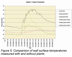 Figure 5 shows the preliminary findings on vertical greenery thermal performance. The results show that the surface temperature of the concrete wall can be easily 10oC higher than the surface covered by the vertical greenery system. The graph also shows that different plants have different abilities. They shade and cool down the surface and are governed very much by the foliage density (Leaf Area Index) of plants. Besides studying the thermal performance, this research will also study the types of plants which are able to withstand strong wind, strong tropical solar radiation and require less maintenance in terms of cost effectiveness. Figure 5 shows the preliminary findings on vertical greenery thermal performance. The results show that the surface temperature of the concrete wall can be easily 10oC higher than the surface covered by the vertical greenery system. The graph also shows that different plants have different abilities. They shade and cool down the surface and are governed very much by the foliage density (Leaf Area Index) of plants. Besides studying the thermal performance, this research will also study the types of plants which are able to withstand strong wind, strong tropical solar radiation and require less maintenance in terms of cost effectiveness.
 Click here to download the full issue for USD 6.50 Click here to download the full issue for USD 6.50
|